Cotswolds – Northwest
With the Cotswolds on our doorstep, we are very lucky. Wonderful scenery, lots of punchy climbs and rolling roads.
Webby’s Full English
Distance: 102.4km
Elevation gain: 773m
Description: A flatish start to the day, but don’t be fooled! After some joyous rides across the Thames Valley it’s time to head north in to the Cotswolds for a spot of climbing before heading back in to Oxford from the North. What’s not to like, but watch out for the fords! And the reason for the route title? When first ridden in June 2017, the group headed back to the home of OCC member, Andrew Webb, for a full English breakfast!

Mike’s Midweek Chadlington Loop
Distance: 73.7km
Elevation gain: 711
A great weekday/evening length Cotswold ride – undulating and no overly challenging climbs, so a good one for a group of mixed ability. Out via Eynsham, then quiet roads to Chadlington via Leafield. Cafe de la Poste stop in Chadlington perhaps? Followed by a great spin home, north of Charlbury on backroads, then out of Kiddington and fast back to town via Bletchingdon and Kidlington. Not advisable when the weather poor or in winter, as some of the roads are a little ragged.
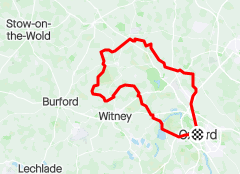
Short, but perfectly formed
Distance: 88km
Elevation gain: 781m
Description: Undulating, but not too many big climbs. Out via Marston, then familiar route through Islip and Enstone, then onto Charlbury and crossing the A40 just west of Witney, before looping back from the SW into Oxford via Boars Hill. Scope to increase the length by looping further south on final third.

Marky Mark’s Cotswold Classic
Disance:109.2km
Elevation: 909m
Description: An absolute belter of a ride devised by Mark Howard and first ridden by the club in September 2017. It was an instant hit with all lucky enough to enjoy the early autumn sunshine! It’s a Cotswolds ride, but taking an unusual route out of the city via Boars Hill, then wiggling its way via Fyfield, Bampton and Brize Norton, before exploring some quintessential Cotswold scenery and villages to the north of Burford. The undulating road home takes you through some familar villages, including Leafield, Finstock and Eynsham.
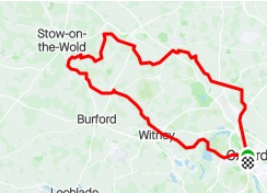
Bourton-on-the-Water and back
Distance: 105km/65 miles
Elevation: 867m
Description: A Cotswold loop for when the wind is coming from the northeast. It starts off relatively benign, but just before Burford, the undulations begin, including the long trawl from Great Barrington to the Rissingtons, before turning for home via the infamous Charlbury Rollers and back into Oxford via East End, Freeland and the Eynsham toll bridge and through Farmoor.

Stow-on-the-Wold
Distance: 103km
Elevation: 1030m
Description: A classic Cotswold route with all the climbing you want on a ride like this with the chance of the usual breakaway shenanigans back through Farmoor. Be careful coming down out of Atow and be sure not to miss the high speed left hander by the lights. Getting through Witney can be tricky, especially after the A40 underpass turning right to High Cogges.
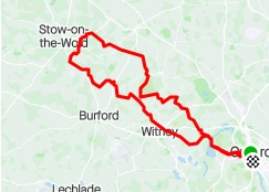
Connor’s Cotswold Classic
Distance: 85 km
Elevation: 850 m
A rolling ride, ideal for a midweek work out, or shorter spring or autumn ride, taking in some of the most stunning roads in the Cotswolds and some of the quietest too. A possible stop at Chadlington for coffee may be too early for some, but this is a ride that packs quite a punch – plenty of long drags and some bumpy bits in-between, so you might need a slice of cake to sustain you. The lactic acid begins to bite on the run-in to Oxford, but this is a feel-good route to savour!

Out to the Rissingtons
Distance: 105km
Elevation gain: 800m
Description: A classic dose of the Cotswolds in this ride, with potential for lots of tailwind on the way back and a chance for some heroics along the Charlbruy Rollers. The long drag up from Great Barrington to the Rissingtons can be a killer so don’t burn too many matches before then.

The Club Secretary’s Cotswolds Killer
Distance: 118km
Elevation gain: 1250m
Description: A lumpy route into the Cotwolds that heads north towards Bletchington, before veering off on a large clockwise loop taking in Charlbury, north of Chipping Norton and back via familiar roads through Great Tew, Somerton and Kirtlington. Not for the faint-hearted! Devised by the original Club Secretary, Brian Cooper.

Cotswolds – West
The southern Cotswolds edges on to the flatter land due west of Oxford before reaching the Vale of the White Horse further south. Many hidden gems lie out this way such as the Coln Valley and less-well-hidden Bibury.
Quintessential Cotswolds
Distance: 102km
Elevations: 816m
Out of Oxford via Eynsham looping north of Witney and Burford before heading back via the Thames Valley. Plenty of quiet roads with some spectacular panoramic views to enjoy. Burford offers a potential cafe stop.

Midweek Lardy Cakes
Disance: 84.5km
Elevation: 612m
A great midweek ride or shorter, social club ride. It’s a lumpy route to Burford, with optional (obligatory?) stop at Huffkins for coffee and lardy cake. If the wind is from the west, the flat route home via some quiet, stunning roads in the Thames Valley will make for a fast and fun ride back to Oxford, entering the city via Appleton and Cumnor.

West to Eastleach Turville
Distance: 100km
Elevation gain: 551m
Description: Flat-ish westerly into the Cotswolds, via Brighthampton, Aston, north of Carterton. Through the picturesque villages of Eastleach Turville and Southrop before heading back via Clanfield, Bampton and back into Oxford ia Bucklan and Appleton.

“Got a spare 2 hours?”
Distance: 47km
Elevation gain: 281m
Description: As the name suggests, a short spin around the back of Oxford for when you have to get out, but can’t truly break free . . .

The Hell of the West
Distance: 116km
Elevation gain: 1270m
Description: An absolute classic ‘Cotswold Lumpy’, no comfort zones here.

Coln Valley Scenic
Distance : 105.5km
Elevation gain: 889m
Description: A stunning ride through some lovely villages, dodging the tourists. A coffee stop at Sherborne is highly recommended.

North Oxfordshire
There are fewer routes due north, with very different riding east or west of the Cherwell Valley. Turn west at Somerton and you’re in for a leg-testing series of lumps through to Hook Norton and beyond. Turn east to the flatter, wider, rolling roads of Northamptonshire.
Northern Escape
Distance: 107km
Elevation gain: 780m
Description: This scenic route takes in some of the Cotswolds, North Oxfordshire and Northamptionshire. Not too hilly but with some uphill drags for bragging rights, it’s potentially a fast ride with the right tailwind.

Circular Route North
Distance: 105km
Elevation gain: 770m
Description: A great circular sweep north of Oxford. Out via Eynsham looping round and back via quiet roads towards Brill then back into Oxford via Stanton St John. A cracker!

Hinton-in-the-Hedges
Distance: 98km
Elevation gain: 760m
Description: This scenic route takes in some of the Cotswolds, North Oxfordshire and Northamptonshire. Not too hilly but with some uphill drags for bragging rights, it’s potentially a fast ride with the right tailwind.

The Astons
Distance: 64km
Elevation: 520m
Description: A well known shorter route which uses one of the default runs north out of Oxford. Pretty flat, it loops back after Somerton through the Astons, Tackley, Onslow and back generally to Oxford again. Good for a shorter winter club ride or solo ride within three hours.

Northern Powerhouse
Distance: 113.6km
Elevation: 806m
Description: This route feels pretty flat but it’s picturesque and potentially tough. Lovely quiet roads north of Brackley lead to fast flats on the way back from the A422.

Punchy Northern Cotwolds
Distance: 104km
Elevation gain: 1000m
Description: North Oxforshire lumpy loop out via Charlbury and Chippy, back via the Tews, Somerton and Kirtlington and back into Oxford through Summertown.

Northeast of Oxford
Perhaps our least-travelled direction given the prevailing southwesterly winds, and the well populated (and therefore busier) area west of the Chilterns, but there are still some great routes, all thankfully avoiding Bicester.
Botolph Claydon with Easterly return
Distance: 96km
Elevation gain: 832m
Description: Quiet, scenic route, perfect for when the wind is coming in from the NE.

Storm Raiders!
Distance: 85km
Elevation gain: 510m
Description: A shorter ride, for rain avoidance or minimization! Northeast clockwise to the Claydons, flat out and little lumps all the way home.
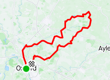
East-Northeast 50 Miler
Distance: 80km
Elevation gain: 909m
Description: Suitable for an easterly tailwind return, this is lumpy ride for the distance. Good for a medium club ride when a flat course just won’t do.

Beast The East
Distance: 97km
Elevation gain: 662m
Description: North to Somerton then east around Bicester on flat, car free roads. A real blast and a favourite route of Club Sec. Mike. Has a sting in the tail with the ascent of Brill followed by Col de Stanton St John.

The Wind In The Winslows
Distance: 85-90km
Elevation gain: 688m
Description: Brill the hard way, then flat mostly to Winslow. A real blast home on flattish roads. A choice can be made at Otmoor – left (as on the map) is the lumpy way, right around Otmoor is a flat and fast alternative.

Chilterns
Southeast of Oxford is also very rural with quiet roads and both lumpy and flat routes can be found out to the Chiltern range. Once climbed, the Chiltern ridge roads are awash with cyclists.
Chilterns via Brill loop
Distance: 108km
Elevation: 1088m
Chilterns loop created by Webby. A great route featuring some excellent roads a little further east than the club often rides. First ridden in May 2018. Heads out via Marston, flirting around Brill before looping southwest into the Chilterns and tracking the hills. Hilly, but the final third is surprisingly fast and undemanding.

Quattro Staggione
Distance: 83km
Elevation gain: 702m
Description: A scenic Chilterns 50 miler for midweek or maybe winter weekends. Designed to avoid busy commuter traffic on the way out and to dip into the Chilterns without too much climbing.

Chilterns Henley Loop
Distance: 105km
Elevation gain: 1020m
Description: A cracking ride at any time of the year, but particularly good in Summer or Autumn, when the leaves are turning, The route exits and returns to Oxford via Stadhampton and Littlemore and takes in some of the prettiest villages that the Chilterns have to offer, like Fingest and Turville. You’ll have to negotiate several good climbs and long descents as you make your way out and back to Henley-on-Thames.

Stretching the Legs
Distance: 109km
Elevation gain: 1121m
Description: Out to the Chilterns via Watlington, before looping back north of Thame and coming into Oxford from the northeast, this ride overs lots of flat terrain for the fast stuff and yet has more than its share of punchy climbs. Take care on all the descents in the Chilterns and the flats into Owlswick and Worminghall.
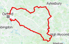
The Chill Turns
Distance: 99km
Elevation gain: 770m
Description: Yep, another run down south to the Chilterns – geddit?! Not too many climbs but lovingly placed to hurt all the same. Fast out and back but keep some juice for the approach Cuddeston.

The Ridgeway and Lambourn
Southwest is probably our favourite direction in the summer months. Flat and fast roads through the Vale Of The White Horse, leading out to some tough climbs up and over the Ridgeway, over Sheepdrove or through the Valley Of The Racehorse, and back home fast with the wind at our backs! Glorious.
65 mile anti-clockwise loop to Lambourn, via Chimney Meadows
Distance: 105km Elevation gain: 714
Description: One for a southerly/southwesterly wind. Heading out via Cumnor Hill, Standlake and Brighthampton, Chimney Meadows and then south towards Lambourn, taking in Ashbury Hill, and back via Childrey. East Hanney and back into town over Boars Hill.

Figure of 8 to Lambourn
Distance: 96km
Elevation gain: 670m
Description: Perfect for when the wind is blowing from the Southwest. Out via Boars Hill, with a little jig underneath the A420 trunk road, followed by a lovely stretch of tarmac from Kingston Bagpuize all the way to Denchworth. South to Lambourn via the quiet and panoramic Sheepdrove Road. A cracker and rightly an OCC favourite!

Ridgeway loop into Lambourn via Sheepdrove
Distance: 102km
Elevation gain: 735m
Description: A good ride for a strong SW wind. Out via Boars Hill, before picking its way toward Kingston Bagpuize to take in the smooth asphalt roads to West Hanney and Denchworth. Over the Ridgeway via Childrey and the the quiet Sheepdrove private road into Lambourn. Back via Ashbury, a quick wiggle west before turning for home and fast back from Shrivenham!

Aldbourne Roads Less Travelled
Distance: 108km
Elevation: 818m
Out via familiar roads to Lambourn, with the long slog up to Sparsholt Firs the only big climb of the ride. Rather than turning for home at Lambourn, this route takes us on a rare sortie over the M4 followed by a fast, long descent into Aldbourne and the lovely gentle climb back out of the valley via Lottage Road. The route flits around the western fringes of the Ridgeway, via backroads into Shrivenham and fast back to Oxford, with a detour via Charney Bassett and Garford and back home via Cothill and the final bump of Boars Hill.

Tailwind Hero
Distance: 112km
Elevation gain: 793m
Description: Despite the impression this will be a windy Windrush Valley sortie, there is a healthy dose of climbing once the route crosses into and across the Vale of the White Horse. With a southerly wind, it should make for a fast return home for those with the legs left to strut their stuff.

Valley to Vale 50 Miler
Distance: 85km
Elevation gain: 450m
Description: This ride is a combination of Windrush valley and Vale of the White Horse roads. It explores some of the quieter lanes around Yelford and Cote before riding over to well known roads to the south west. It takes advantage of S & SE winds on the return and is designed as a medium club ride with a downhill finish.

Sheepdrove Diversion
Distance: 103km
Elevation gain: 808
Description: A fast, relatively easy out to Lambourn, then the fun begins with some wonderful climbing up to one of our favourite roads – Sheepdrove, leading us back down the Ridgeway.

Off-road: local tracks and trails
Thames Path, Radley College and Boars Hill loop
Distance: 25km Elevation gain: 230m
Description: Out of town via the Thames towpath south, then up through Radley woods, through the grounds of Radley College and then to Boars Hill, via Woodcraft Wood. Enjoy the big climb up the field from Chiswell Farm, before looping back past the Priory before descending back into town via Westminster College Hill, North Hinksey and Willow Walk.

Faringdon Folly loop
Distance: 63km Elevation gain: 420m
Description: A longer workout, with a great mix of tracks, with occasional respite on asphalt. Out over Boars Hill, through Besselsleigh Woods before a stretch of asphalt before heading onto paths that connect small villages all the way to Faringdon with some fantastic views towards Brize Norton and the Cotswolds. Coffee at Stay Grounded in Faringdon recommended, before heading home with a quick stop to check out Farringdon Folly. A mix of tracks including an overgrown former golf course back to Pusey, then through the piggie farm into Kingston Bagpuize before a final flourish through Cothill Woods and back over Boars Hill via the Scout Camp road.

Northern Classic gravel
Distance: 71km
Elevation gain: 637m
Great mix of woodland, gravel, canal towpath and more, with a stop at the Old Shed just north of Charlbury for a well-earned coffee and apple frangipane also factored in. Back into Oxford via the canal path and into Jericho.

Towpath to Abingdon and over the Ridgeway
Distance: 78km
Elevation gain: 517m
Starting from Folly Bridge, just south of St Aldates, then to Abingdon via the Thames towpath, before heading up and over the Ridgeway, with a stop at the Saddleback Farm Cafe in Farnborough. Long socks in nettle season advisable


